

DANGEROUS, LIFE THREATENING STORM SURGE AND FLOODING. WATCH THE VIDEO INCLUDED IN THIS POST FROM NOAA / NWS / NATIONAL HURRICANE CENTER. HURRICANE FLORENCE gains strength, the governors of North Carolina, South Carolina, and Virginia and the U.S. Navy take responsible steps preparing for landfall later this week. Flooding from the storm surge and heavy rains will be the most dangerous aspects of Florence, people should heed evacuation orders and have water and non perishable food available. AND REMEMBER, DO NOT DRIVE ON FLOODED ROADS, TURN AROUND, DO NOT DROWN!!!!! From NPR.....
Hurricane Watch Issued For Carolinas Ahead Of Category 4 Florence

Hurricane Florence "is expected to be an extremely dangerous major hurricane through Thursday night" – and the Category 4 storm has now triggered a hurricane watch for all of North Carolina and part of South Carolina, the National Hurricane Center says.
Florence is packing maximum sustained winds of 130 mph, with higher gusts, the hurricane center said in its 8 a.m. ET update. At the time, the imposing storm was 405 miles south of Bermuda.
Florence is expected to hit the Carolinas and Virginia late Thursday or early Friday. It's currently predicted to make landfall somewhere north of Wilmington, before its center heads inland toward Raleigh and Durham. As of 8 a.m. ET, the hurricane was moving west-northwest at 15 mph, with maximum sustained winds of 130 mph.
The storm will pick up additional strength as it passes over ocean water with sea surface temperatures of up to 85 degrees, the National Hurricane Center said.
The large and powerful hurricane has prompted evacuation orders in North and South Carolina and Virginia, as officials urge residents in coastal and low-lying areas to prepare for strong winds, a deep storm surge, and a deluge of rainfall that could last more than 24 hours.
Florence will bring a perilous risk of flooding to a broad area, and its wind and rains will also bring downed trees and other destruction to areas in its path, the hurricane center said.
"All the rainfall we're going to have, plus you talk about the wind — that means a lot of trees coming down, it's a lot of power outages, a lot of impacts with this system," NHC director Ken Graham said on Tuesday.
The hurricane watch notice is significant because it signals the opening of a 48-hour window for the expected first arrival of tropical-storm-force winds. After that point, it would be difficult for people in the storm's path to either finish preparations or flee affected areas.

On Tuesday morning, data from an Air Force Reserve hurricane hunter aircraft found that Florence's sustained winds had weakened somewhat from the 140-mph speeds reported earlier. But the storm is expected to restrengthen over the next day or so.
A hurricane watch is now in effect for hundreds of miles of the U.S. East Coast, from Edisto Beach in South Carolina up north to the North Carolina-Virginia border. Tropical storm conditions could hit those areas by Thursday morning, forecasters say.

If it makes landfall as predicted, Florence could become the northern-most Category 4 hurricane to hit the U.S. since records were first kept in 1851. It's expected to strike far above the point where Hurricane Hazel arrived close to the South Carolina/North Carolina border in October 1954.
In addition to strong winds, Florence brings the threat of a devastating storm surge – as high as 6-12 feet in the area from Cape Fear, N.C., to Cape Lookout, N.C.
"Prolonged and exceptionally heavy" rains will also inundate parts of the coast and inland areas, the National Hurricane Center said:
"Florence is expected to produce total rainfall accumulations of 15 to 20 inches with isolated maxima to 30 inches near Florence's track over portions of North Carolina, Virginia, and northern South Carolina through Saturday. This rainfall may produce life-threatening flash flooding."
Florence is expected to stall over North Carolina and slowly make its way across the state and into southwestern Virginia. The hurricane center predicts a "heavy rainfall event, which may extend inland over the Carolinas and Mid-Atlantic for hundreds of miles."
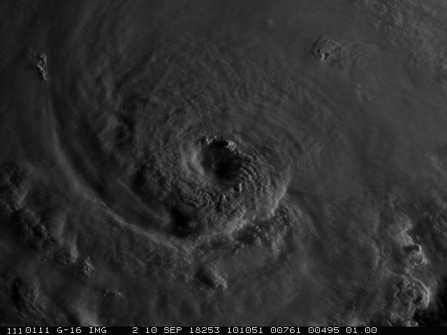
Overnight, Florence went through an "eyewall replacement cycle," Senior Hurricane Specialist Stacy Stewart said in an update from the hurricane center on Tuesday.
"That's good news and bad news," he said. "It's weakened, but unfortunately the eye has expanded out to a diameter now of about 30-35 nautical miles."
Stewart added, "We're going to have a fairly stable, powerful hurricane with the potential for some additional slow strengthening over about the next 24 hours."
Florence Gains Strength As A Category 4 Hurricane, Aiming At U.S. East Coast

Updated at 5 a.m. ET on Tuesday
Hurricane Florence is growing in size and strength as it barrels toward the Southeastern U.S. for an expected landfall in the Carolinas later this week as an "extremely dangerous hurricane," according to the National Hurricane Center.
A hurricane watch has been issued for the U.S. east coast from Edisto Beach, South Carolina to North Carolina-Virginia border, including the Pamlico and Albemarle sounds., with storm surge watches encompassing the same area.

Swells generated by the hurricane are already affecting portions of the East Coast and Bermuda. The center said the powerful waves are likely to cause life-threatening surf and rip current conditions. Additionally, Florence, about 1,000 miles southeast of Cape Fear, N.C., is predicted to bring "life-threatening impacts" to North Carolina and neighboring states late this week.
Mandatory evacuation orders have been issued by the governors of North and South Carolina and Virginia for coastal areas.
The storm quickly strengthened on Monday and by midday was reclassified as a Category 4 hurricane, reaching that status a day earlier than experts had predicted. The hurricane center cited data from a NOAA Hurricane Hunter aircraft that showed Florence was rapidly intensifying, with maximum sustained winds near 140 mph.
In an earlier update, officials said Florence's winds could reach 150 mph over the next 36 hours. The storm is already 500 miles wide — meaning a large area will be at risk when it nears land. The NHC says hurricane-force winds can be expected 40 miles from the center of Florence, while tropical-storm force winds extend out 150 miles.

The hurricane's impacts could range from a strong storm surge to flooding from torrential rainfall and hurricane-force winds. Forecasters warn that the predicted track is likely to change — but for now, it shows the strong hurricane bearing down on the North Carolina coast, with a potential landfall north of Wilmington.
Once it makes landfall, Florence is predicted to stall and remain over North Carolina for at least 24 hours — increasing the threat of dangerous flooding, NHC Director Ken Graham said on Monday. Even in areas far from the coast, he added, parts of North Carolina and Virginia could see rain totals of 10-15 inches over the next seven days.
As of 5 a.m. ET Tuesday, Florence was moving at 15 mph, some 500 miles south-southeast of Bermuda, the hurricane center said.

This incredible loop from #GOESEast shows Hurricane #Florence churning in the Atlantic. The storm is strengthening rapidly and is expected to become a major hurricane very soon. Latest: go.usa.gov/xPx5F
As it nears the U.S. Atlantic shore, Florence will also benefit from "very warm" sea surface temperatures of up to 85 degrees, the hurricane center said.

As meteorologist Stu Ostro of The Weather Channel reports via Twitter, since 1851, only four Category 4 hurricanes have made landfall north of Florida on the East Coast. The northernmost landfall was made by Hazel, a devastating and deadly storm that struck close to the South Carolina/North Carolina border in October 1954.

For historical perspective, only four Category 4 landfalls on the East Coast north of Florida in the official list bit.ly/1MaPQ9T going back to 1851, the farthest north being on the SC/NC border (Hazel)
Forecasters say Florence will pass between Bermuda and the Bahamas on Tuesday and Wednesday and start its approach to the U.S. on Thursday morning. Tropical-storm-force winds are expected to start to reach the coast of the Carolinas on Thursday, the National Hurricane Center said.
As the danger became clear over the weekend, the governors of North Carolina, South Carolina and Virginia all declared states of emergency. They urged residents to fortify homes and gather supplies.
The U.S. Navy is also taking precautions, with the U.S. Fleet Forces Command ordering nearly 30 ships in the Hampton Roads area of the Virginia coast to head out to sea to avoid the storm. Vessels that can't leave port will prepare by a variety of means, from adding mooring and storm lines to dropping anchor and disconnecting shore power cables.

Florence is currently projecting hurricane-force winds (74 mph and higher) up to 30 miles from its center. Forecasters say that because of the size the storm is expected to attain, it will wreak havoc regardless of how strong its winds are.
In addition to a storm surge and winds, the National Hurricane Center says:

Florence is one of three hurricanes in the Atlantic Ocean, along with Helene and Isaac. Of the two other storms, which remain far from land, Isaac poses the most immediate risk. With winds of 75 mph, it's expected to strengthen a bit before weakening as it approaches the Lesser Antilles on Thursday.
Dangerous storms are also threatening parts of the U.S. in the Pacific Ocean. Most of the state of Hawaii was under either a tropical storm warning or watch on Monday morning, as Hurricane Olivia bears westward, with 85 mph winds.
Olivia could weaken into a strong tropical storm within 48 hours, according to the Central Pacific Hurricane Center in Honolulu. But forecasters say residents should still beware of the chance for dangerous flooding and wind.
In Guam, Typhoon Mangkhut — a Category 4 storm — narrowly missed dealing a direct blow to the island.
No comments:
Post a Comment