NORTON META TAG

Showing posts with label weather. Show all posts

16 July 2026

Why we use dew point instead of relative humidity 15JUN26


Why we use dew point instead of relative humidity



Published:
When we describe how humid it feels outside, you'll almost always see us talk about dew point instead of relative humidity.

Relative humidity gets a lot of the attention. But when it comes to describing how muggy the air actually feels, it's often misleading.

Dew point tells the story much better.

Think of dew point as a direct measure of how much moisture is in the air. More specifically, it's the temperature to which the air would have to cool before becoming saturated and producing dew.

This may sound technical, but the takeaway is simple: the higher the dew point, the muggier it feels.

Relative humidity, on the other hand, doesn't tell you how much water vapor is actually in the air. Instead, it tells you how close the air is to being saturated at its current temperature.

Cool, saturated air often contains less moisture than hot air that's not even close to saturated.

Consider two afternoons:

  • Day A: 72 degrees with 80 percent relative humidity
  • Day B: 92 degrees with 45 percent relative humidity

Most people would assume Day A is more humid because the relative humidity is nearly twice as high. In reality, there's more moisture in the air on Day B.

[How humid does it get in DC? A look at dew points through the year]

The key is that relative humidity measures how close the air is to saturation — not how much moisture is actually in the air. Since temperature plays such a big role, relative humidity can change dramatically even when the amount of moisture stays exactly the same.

Consider a crisp autumn morning with a relative humidity near 100 percent. Overnight cooling pushes the air close to saturation, driving up the relative humidity even though there's not much moisture in the air. It may be damp enough for dew or fog to form, but it certainly doesn't feel muggy.

Dew point cuts through that confusion because it measures the moisture itself.

It gives us a much better sense of whether you're stepping into comfortably dry air or the kind of soup that leaves your shirt sticking to your back after a five-minute walk.

Around the DC area, summer dew points routinely climb into the upper 60s and low 70s. During the most oppressive heat waves, they can rise into the mid-70s and occasionally approach 80. At those levels, the air feels heavy, perspiration evaporates less efficiently, and simply being outdoors becomes exhausting.

It's also why visitors from the West are often surprised by summers here. Places like Phoenix and Las Vegas may experience much higher air temperatures, but their dew points are frequently 30 or even 40 degrees lower. The heat can be extreme, but it's a different kind of heat because the air contains much less moisture.

Relative humidity still has its uses. It's important in forecasting fog, clouds, and whether the air is nearing saturation. But if your question is simply, "How humid is it going to feel?" there's a better number.

So when we're talking about how humid it's going to feel, you'll hear us focus on dew point far more often than relative humidity. We think it's the most accurate —and most useful — way to describe what you'll actually experience when you step outside.


28 January 2026

VIDEO: CAT STEVEN'S MOONSHADOW & FEBRUARY'S FULL MOON IS THE SNOW MOON, MAKING IT'S APPEARANCE ON 1 FEBRUARY 2026. 27JAN26


                            PHASES OF THE MOON from the Old Farmer's Almanac

The Snow Moon is certainly living up to its name in 2026.


Scott SutherlandMeteorologist, Science Writer

Published on Jan. 27, 2026, 5:21 PM

Check 2026 astronomical events here. This from the Weather Network ( Canadian ).....

If you have reasonably clear skies this weekend, take a few minutes to observe the night sky and especially this year's Snow Moon.

The next Full Moon occurs on Sunday, February 1. On that day, the Sun, Earth, and Moon will line up, with sunlight illuminating the entire near-side of our celestial companion. From just before sunset to just after sunrise the next morning, the Moon will be up all night long.

However, according to NASA, the Moon will appear full (over 98 per cent illuminated), from Saturday night through Tuesday evening. This is due to the fact that, with the Moon being over 370,000 kilometres away, it is challenging to spot the 1-2 per cent of the Moon that is in shadow on the days before and after the official date of the Full Moon.

Check your local forecast, via our website or app, to see if your sky conditions are right for viewing.

For over a century, the first Full Moon of each month has had a popular name assigned to it. Any 'bonus' Full Moon, like the one we see at the end of May in 2026, is called a "Blue Moon".

The February Full Moon, when we have them, is known as the Snow Moon.

"February is typically a time of heavy snowfall," says The Old Farmer's Almanac. Other names they include, which are mostly taken from Indigenous lunar calendars, are Bear Moon, Eagle Moon, Raccoon Moon, Groundhog Moon, and Hunger Moon.

This graphic collects all 13 Full Moon of 2026, including their popular names, whether they are a 'super' or 'micro' Moon, a perigee or apogee Full Moon, and whether they are remarkable in some other way (Lunar Eclipse or Harvest Moon). Credit: NASA's Scientific Visualization Studio/Scott Sutherland

READ MORE: Why does the Moon look so big? What is the mysterious Moon Illusion?

Some Indigenous peoples named the February Moon after animals, such as the goose (the Haida and the Omaha), the rabbit (the Potawatomi), the crow (the Shawnee), the coyote (the Shoshone), or the black bear (the Tlingit). There are also references to cold (the Lakota and Wishram), frost (the Algonquin and Arapaho), and sleet (the Comanche).

The Kalapuya of the Pacific Northwest refer to it as "atchiulartadsh" which translates to "out of food" and could be a possible reference for 'Hunger Moon'.

It should be noted that, in Indigenous lunar calendars, these names are not for just the Full Moon. Instead, they actually refer to the period from one New Moon to the next. Following along from previous 'lunations', this Snow Moon began after the January 18 New Moon, and will end just before the February 17 New Moon.

Given the weather across Canada, especially in the last week of January, the Snow Moon is definitely living up to its name this year.


Parts of southern Ontario, and especially in the Greater Toronto area, are still digging out from the historic snowstorm that impacted the region on January 25. The intense storm buried downtown Toronto in over 60 cm of snow. Meanwhile Pearson International Airport reported a record-setting single-day snowfall amount of 46 cm.

This same storm system also dropped up to 20 cm of snow across southern Quebec, with blowing snow becoming a major problem as gusting winds lofted this dry light snow into the air, reducing visibility and creating hazardous travel conditions.

This winter storm is now lingering across Atlantic Canada, dropping up to 10 cm of snow on New Brunswick, PEI, much of Nova Scotia, the most of the island of Newfoundland. Parts of northern Cape Breton Island and eastern Newfoundland saw up to 20 cm.

And although the above map shows snow cover as of January 27, rather than on February 1, due to the frigid air that has enveloped much of the country, that snow is going to stick around for some time.

12 July 2024

Severe drought is expanding over the D.C. area. Will meaningful rain ever come? 12JUL24

DROUGHT in the U.S. is not just a Western U.S. phenomenon and along with drought comes the increased risk of wild fires.  Water is life and we have to stop acting like we are entitled to waste it. So at home if the water in your toilet is yellow it is mellow, if it is brown flush it down. Stop wasting water by rinsing dishes before loading in the dishwasher. Use the auto-fill setting on your washer to avoid over filling with water. Take quicker showers, and unless your hair gets really dirty because of your job or activities cut back to washing your hair once a week. At restaurants don't ask for water or tell your server you don't want any water if you are not going to drink it. Water your garden at dusk to give plants time to absorb water before it evaporates, limit watering your lawn to once a week (STOP mowing you lawn until the drought is over). From the Washington Post.....

Severe drought is expanding over the D.C. area. Will meaningful rain ever come?

It’s one of the hottest and driest summers on record, but there may be some relief ahead.

July 11, 2024 at 12:13 p.m. EDT

Ian Livingston is a forecaster/photographer and information lead for the Capital Weather Gang. By day, Ian is a defense and national security researcher at a D.C. think tank. Twitter

The drought has come on quickly, meeting criteria for a “flash drought” because of its rapid onset. It began in June and has shown little sign of abating. It was the driest June on record in Virginia and also abnormally dry in neighboring states.

July has picked up where June left off. Thundershowers that swept through the region Wednesday night produced minimal rainfall, and most of the area has 3 to 4 inches less precipitation than normal so far this summer.

Percent of normal precipitation. (Ian Livingston)

The drought has worsened because of a vicious feedback cycle in which hot sunshine dries out the ground and causes temperatures to rise. The rising temperatures then speed up evaporation, which dries out the ground even more.

Drought change over the past month. (Ian Livingston)

The District is enduring its second-hottest summer on record so far, and Wednesday was the sixth consecutive day to reach at least 97 degrees, the second longest such streak on record.

Here’s how bad the drought is

A group of roofers take a lunch break after battling 95-degree temperatures Wednesday. (Ricky Carioti/The Washington Post)

The progression of the federal government’s drought monitor in recent weeks shows how drought has quickly expanded and intensified across the region.

Much of the area is now in moderate to severe drought, the second and third levels on a 1-to-5 scale.

While the intense heat has made the drought worse, its primary cause is the lack of rain. June and July are the region’s wettest months, but sunny skies have dominated.

The District has a rainfall deficit of 4.5 inches since June 1. Only 1.54 inches have fallen since then, third least on record. Baltimore and Dulles have received only 1.6 inches (eighth driest on record) and 1.75 inches (second driest on record), respectively, over the same period.

Precipitation during the past 30 days. (Ian Livingston)

The lack of rainfall has coincided with the summer solstice period when the sun is most intense. As a result, vegetation is suffering, with lawns turning brown and trees and other vegetation lacking water.

An improved outlook for rain

Some good news: Substantial rain could fall Friday, especially along and east of Interstate 95, where an inch or more could fall. Amounts will decrease to the west.

Predicted rainfall through Saturday morning from the National Weather Service. (WeatherBell)

Unfortunately, another round of excessively hot weather is predicted between Sunday and the middle of next week. Highs well into the 90s or even around 100 will quickly dry out the land surface again.


But after next week’s heat wave, a more promising weather pattern for rain could develop. The area is expected to sit between heat domes in the Southwest United States and western Atlantic Ocean, which will result in a southerly air flow.

While that will elevate humidity, it should also increase the potential for showers and thunderstorms.

The weather pattern forecast in 10 days from the European ensemble model shows an opening for more rain as the region sits near a dip in the jet stream between dominant heat domes. (WeatherBell)

If the remnants of a tropical storm or hurricane passed over the area, that would be the easiest way to dig out of the rainfall deficit. An active hurricane season is predicted, but there are no imminent signs of any storm that would turn into a big rainmaker for us.

19 November 2016

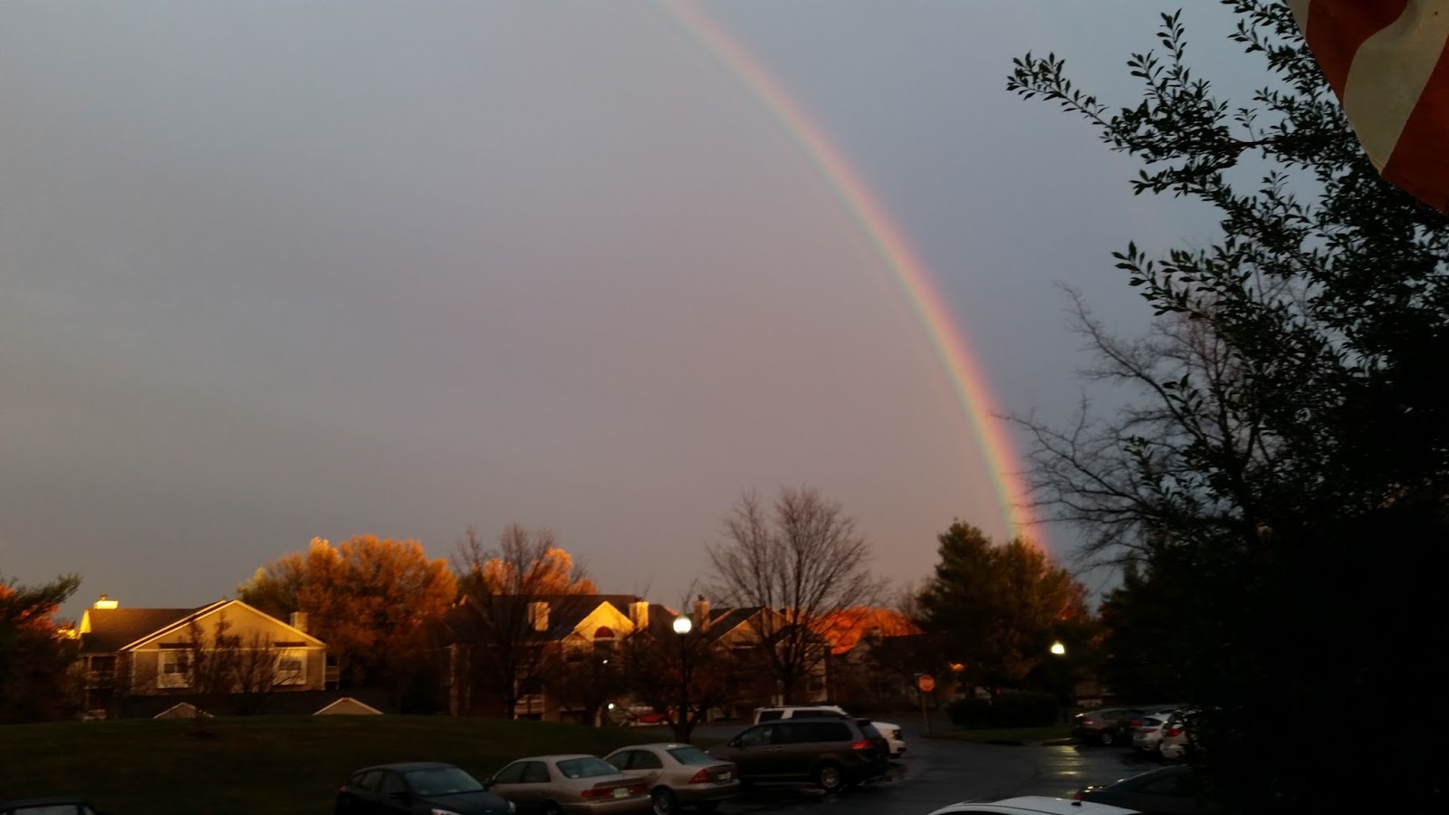
RAINBOWS IN ASHBURN, VA 19NOV16

I love rainbows, and these were really beautiful. As usual the pictures don't do them justice, the colors were so bright and vibrant! It was sunny and warm here (Ashburn, VA) this morning, then a front moved through, really windy and sleet / hail, 27 mph gust, and it is now 42F / 38F wind chill. But we were treated to a beautiful double rainbow!


22 March 2014

SLOBOBIAN WABBIT & TANNHAUSER BUGS BUNNY VIDEOS & NEXT TUESDAY'S (25MAR14) WEATHER FORCAST FOR NORTHERN VA & METRO D.C. 21MAR14

SPRING, I am seekingk for you you are hidingk from me....
http://youtu.be/CCtO_WdsdqM
SO Spring, my wuve, weturn to me, pwease!!!!!
http://youtu.be/6jDcWAWRRHo 


Don’t panic, but a ‘Nor’easter bomb’ might bring snow to the East Coast next week


Snow-covered tables in Washington, D.C., earlier this week. (Nicholas Kamm/AFP/Getty Images)
People of the East Coast, I bring sad and frigid news about what this unending winter might deliver next week. The National Weather Service released a warning that a “Nor’easter bomb” could be in store for the Mid-Atlantic on Tuesday night.
Here’s where I pause for a moment to note that this is just a forecast made several days in advance, and obviously with such forecasts you must remember that they are merely scientific pronouncements about what may happen rather than hard and fast declarations stating what will happen. The NWS notes in its warning that this is all about potential, so keep that in mind.
Here’s what the NWS says:
“The east-coast cyclone has the potential to produce late-season heavy snowfall over a wide swath of real estate from Virginia to New England; that is a generality at this point. Much remains in terms of refining the forecast state by state. Another high-impact factor will be the powerful winds generated by this sprawling, intense circulation, along with high seas, beach battery, coastal flooding, and so forth. Again, at this point, such sensible weather effects are simply attendant to the potential of such a storm.”
(The word “bomb” is used when low-pressure centers deepen at a particularly fast rate, according to Eric Holthaus, who flagged the warning in the first place.)
It’s okay, though, because spring — actual spring, not just the official start of spring, the kind of spring where I can start wearing sandals outside again — is almost here! And with spring comes the salvation of warmth, comfort and — what’s that, Capital Weather Gang’s Jason Samenow?
The spring season will pose challenges of its own, NOAA cautioned today, in releasing its spring outlook…. Drought in California is predicted to persist or intensify and up to half of the rivers in the U.S. are prone to minor to moderate flooding as snow melts and spring rains arrive. Little relief is likely for some of the areas hardest hit by cold.
Oh, and — wait, there’s more from Samenow:
Suppose a strong El Niño event does materialize later this summer or fall. What might it mean?
  • Large amounts of heat from the tropical Pacific Ocean would be released into the atmosphere, likely raising global temperatures to record-setting levels
  • Above normal rain would be favored in California.
  • Hurricane activity would likely be suppressed in the Atlantic
If you’ll excuse me. [climbs into storm bunker, locks the door, sobs quietly]


Next Tuesday’s East Coast storm could be a monster, but could miss


Yes, a major storm  will explode off the East Coast early next week. Sure, call it a ‘meteorological bomb’.  But the potentially behemoth storm may only materially impact eastern New England.
Since yesterday, models have shifted the track of the storm farther offshore and the consensus is trending towards more of a glancing blow scenario for the Mid-Atlantic – including the Washington, D.C. area.  Yes, a slight shift back towards  the coast is possible.  So the entire Mid-Atlantic and especially the Northeast – where the storm center is likely to come somewhat closer – need to stay on alert.
This is a storm that models suggest will rapidly intensify Tuesday into Wednesday, easily meeting the criteria for what meteorologists call “explosive development” or “bombogenesis” in which the storm’s central pressure plummets 24 mb in 24 hours.  These kinds of storms can produce severe impacts including very heavy rain and snow, wind gusts over 60 mph (especially in coastal areas), and coastal flooding.
But for now, the latest models suggest D.C. could well be spared the storm’s full force.
“For the Washington area, the operational models only forecast light precipitation Tuesday, as they develop the low too far east to spread the heavier precipitation into our area,” notes Wes Junker, Capital Weather Gang’s winter weather expert. ” The models also are still suggesting that the precipitation will fall during the day on Tuesday.  Light precipitation during daylight hours could be either rain or snow but would not be a big deal if today’s runs of the operational models are correct.”
But Junker also cautions it’s too soon to let our guard down: “The latest GEFS ensemble guidance offers a big caveat as a few members [simulations] still wrap up the low and spread heavy precipitation/snow into the area.  Therefore, despite the model trends, the storm still is worth monitoring over the next couple of days.”
(The same holds true for the European model ensemble guidance – some simulations have the storm hitting us more directly.)
Let’s take a quick look at the latest operational models.
* The European model is mostly a miss for the D.C. area (and even eastern New England is just grazed), with just a little rain and/or snow Tuesday.
Storm simulation from European model from 8 a.m. Tuesday to 8 a.m. Wednesday (WeatherBell.com)
* The GFS model mostly misses D.C., but would have major impacts in New England, with snow, wind and coastal flooding.
Storm simulation of GFS model from 8 a.m. Tuesday to 8 a.m. Wednesday (WeatherBell.com)
* The Canadian model is pretty similar to the GFS…just grazing D.C. but delivering a blow to eastern New England.
Simulation of storm from Canadian model from 8 a.m. Tuesday to 8 a.m. Wednesday (Environment Canada)
As we’re right on the edge of this, stay tuned for updates over the weekend.

http://www.washingtonpost.com/news/post-nation/wp/2014/03/21/dont-panic-but-a-noreaster-bomb-might-bring-snow-to-the-east-coast-next-week/?wpisrc=nl_headlines

http://www.washingtonpost.com/blogs/capital-weather-gang/wp/2014/03/21/next-tuesdays-east-coast-storm-could-be-a-monster-but-may-well-miss/?tid=pm_pop

http://uswx.com/uswx/local.php?q=20170&x=10&y=11