
NEVER RECEIVED ANY WEATHER ALERT FROM LOUDOUN COUNTY, never heard anything about severe thunderstorms or tornadoes on the radio until the front was passed Leesburg. I wonder how many will have to be killed and injured by tornadoes to meet the Tombstone Factor threshold for Virginia to install tornado warning sirens in vulnerable areas? From the Washington Post.....
A historic winter thunderstorm outbreak with likely tornadoes rocked the D.C. area Friday morning. Here’s how and why.

Left: The National Weather Service Storm Prediction Center was not forecasting thunderstorms in the Mid-Atlantic on Friday as of Thursday afternoon. Right: Reports of damaging thunderstorms in the Mid-Atlantic on Friday. (National Weather Service)

The evolution of a bowing segment producing a "kink in the line" with storms Friday morning. (Radarscope/Jeff Halverson)

Radar indicates debris being lofted into the sky around 7:24 a.m. Note the blotch of yellow, where the radar detected unusual shapes owing to debris tossed about. (NOAA)

"Spectrum width" from the radar indicates a narrow zone of extremely chaotic motions within the storm, associated with a tornado just northeast of downtown Leesburg at 7:24 a.m. (NOAA)

Storm damage on the 100 block of West Main St. in Westminster, Md., on Friday. (Doug Kapustin for The Washington Post)
A historic winter thunderstorm outbreak with likely tornadoes rocked the D.C. area Friday morning. Here’s how and why.
UPDATE, 10:30 p.m.: Five confirmed tornadoes hit the area. For details, see: Weather Service confirms five tornadoes hit D.C. area Friday morning, biggest winter event on record
Original article
During what is typically Washington’s snowiest time of year, a volley of damaging thunderstorms, which likely spawned tornadoes, barreled through the region early Friday morning. An unusually potent and warm February storm system fed abnormally moist, unstable air into the region, fueling the violent thunderstorm complex whose intensity flummoxed forecasters.
Weather radar and damage reports suggest tornadoes may have touched down in Washington’s northwestern suburbs near Leesburg, Va., and in parts of western Montgomery, eastern Frederick and western Carroll counties in Maryland. The National Weather Service forecast office serving the Washington region in Sterling, Va., is surveying the damage in these areas to determine if and where tornadoes occurred.
The Weather Service has logged more than 170 reports of damaging winds in the Mid-Atlantic between the Virginia Tidewater and New Jersey from this event, the most on record during the winter months of December, January and February.
What areas were hardest hit?
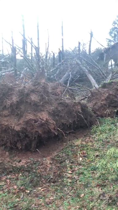
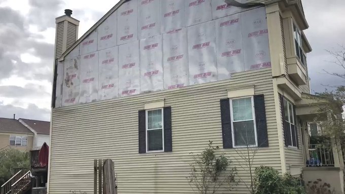
In the Washington region, the area around Leesburg endured the worst damage with many reports of large trees and power lines down and structural damage to homes, including chimneys being toppled at an apartment complex, sheared-off siding and collapsed decks.
Storm damage from the area of Governor’s Drive and Country Club Drive in Leesburg @NWS_BaltWash @capitalweather


32 people are talking about this
The same thunderstorm line that tracked through Leesburg, likely producing a tornado, continued into southwest Montgomery County, where many more trees came down. Structures at a farm near Poolesville, Md., were heavily damaged.
A #tornado appears to have touched down on the @CallevaOutdoors Farm near Dickerson / Poolesville, Maryland. All people and animals were unharmed. Be safe approaching any nearby structures! @capitalweather @wusa9


See Adam Van Grack's other Tweets
Additional reports of damage focused between eastern Frederick and western Carroll counties. Trees were snapped like toothpicks around Monrovia in southeast Frederick County:

As the same thunderstorm charged northeast into Westminster, in Carroll County, large trees came down and a roof was blown off a building on Main Street.


The vigorous line of storms also unleashed scattered reports of small hail and torrential rainfall, which led to some localized flooding in poor drainage areas at the height of the morning commute.
Parts of 16th street are overflowing after this storm. Also saw hail driving through Takoma @capitalweather...
Drive safe everyone!


See Carmel Delshad's other Tweets
How rare was this?
Wintertime tornadoes and severe thunderstorms are rare but not unheard of in the Mid-Atlantic and seem to be increasing in frequency in recent years.
The Mid-Atlantic averages a tornado in February about every other year, and the region sees about one per year on the average between the months of December and February. However, in the past decade, winter tornadoes were more than twice as frequent compared with previous decades (some of this increase is likely related to more spotters reporting these storms).
The biggest tornado event in the broader Mid-Atlantic between December and February happened recently, Feb. 24, 2016, when 12 tornadoes touched down in the broader region. They were focused in southeast Virginia, with a few in Pennsylvania.

In the immediate Washington region, confirmed wintertime tornadoes are more unusual. If the Weather Service confirms more than one twister from this event, this would be the largest tornado event on record in our area between December and February.
The 170-plus reports of damaging winds across the eastern Mid-Atlantic have surpassed any other wintertime event on record in the region. Some of this may be attributable to more people reporting storm damage today than in the past. The previous most damaging storm outbreak in the Mid-Atlantic occurred on Feb. 2, 2009, when there were 130 reports, mainly in the western part of the region. On Feb. 24, 2016 there were 123 reports, mainly in the east.

How these storms erupted and why meteorologists didn’t anticipate them
Hindsight is 20-20, and the data was such that forecasters might have been concerned. But confidence is always a struggle in setups in which favorable wind dynamics are present for damaging storms but necessary instability may be lacking — fuel for damaging storms.
A highly energetic storm system, predicted to become a “bomb cyclone," was intensifying over the Mid-Atlantic early Friday while racing northeastward. It was a very dynamic environment, and gusty showers were in the forecast.
However, “the low level environment was kind of tricky,” said Luis Rosa, lead meteorologist at the Weather Service office serving the Washington region. “The Storm Prediction Center [wasn’t even forecasting] general thunderstorms. When we looked at lightning data this morning, it was very sporadic. And we typically see tornadoes in environments with higher dew points [moisture levels].”
The Storm Prediction Center at 1 a.m. Friday had written “severe thunderstorms are not forecast across the contiguous United States today or tonight.” Over 170 reports of severe weather have since been received, but the only forecast of any thunderstorm chances was in South Florida.
Left: The National Weather Service Storm Prediction Center was not forecasting thunderstorms in the Mid-Atlantic on Friday as of Thursday afternoon. Right: Reports of damaging thunderstorms in the Mid-Atlantic on Friday. (National Weather Service)
Bill Bunting, acting director at the Weather Service’s Storm Prediction Center, attributed the misfire to poor model forecasts of the instability that fueled the storms.
“This type of environment is difficult to anticipate in the extended time frame due to the uncertainty of whether or not thunderstorms will even develop," he wrote.
Upon reviewing weather-balloon data, it appears forecasters may have misjudged one key feature: an inversion. That is when temperatures increase, and not decrease, with height. Usually, such inversions quash severe weather chances. In this case, it may have helped them.
Due to the inversion, temperatures near the surface were cool — not warm enough to support tornadoes initially. Such stable, wedges of cold air can be notoriously persistent and resist erosion by milder air trying to invade from the south. This staying power happens so often that forecasters have grown accustomed to assuming this usually will be the case.

Just above the surface, however, lurked a stout layer of warm, moist air. Ordinarily, that would choke off any shot of severe weather or even damaging winds, since “inversion” usually inhibits momentum from reaching the surface. It also keeps storms “elevated,” meaning they are not rooted in air near the ground, limiting a tornado risk even if a rotating storm develops.
But it appears some rain that came through was just enough to “mix out” the inversion and bring warmer air down from above. Dulles was 47 degrees just after midnight, but after a bit of light rain had warmed up to 57 degrees by 7 a.m. That rain also increased surface humidity to 93 percent at 7 a.m., meaning cloud bases would be extremely low. That makes it easier for a tornado to touch down.
Around the same time, a newly-developing low-pressure system just to our west draped a warm front to our north. That helped to “back” surface winds with a subtle easterly component. Warm fronts often impart a little bit of extra twist to storms that form along them.

Meanwhile, a very strong jet stream passing nearby meant there was plenty of wind energy aloft. That change of wind speed/direction from weak southerly or southeasterly at the surface to more southwesterly or westerly up above. Any storm that formed in that changeable environment could begin to rotate.
Just before 7 a.m., the Storm Prediction Center released a special discussion, mentioning that the convective line was beginning to evolve into several bowing segments. That means strong winds aloft had surged them into backward "c" structures with damaging wind in the middle.
The figure below shows the evolution of the bowing line segment that generated probable tornadoes in Loudoun and Carroll counties. Over a 30- to 45-minute span, the segment took on an S-shaped appearance, indicating the presence of a small vortex, or mesocyclone. This same portion of the line tracked from southwest to northeast, from near Leesburg to Westminster, Md. — two areas experiencing significant wind damage and where tornadoes may have touched down.
The evolution of a bowing segment producing a "kink in the line" with storms Friday morning. (Radarscope/Jeff Halverson)
At 7:20 a.m., Doppler radar indicated strong, but broad, rotation within the storm just southwest of Leesburg. Ordinarily during environments like this, you do not get the “clean,” strong signatures of a tornado on radar because they are so shallow and quick-hitting.

Sometimes they spin up between radar scans. Issuing a tornado warning for every marginal area of rotation in this environment would result in massive overwarning; not issuing a warning can be fatal. These type of tornadoes are dreaded by meteorologists, because they often cannot see them on radar until it is too late.
However, at 7:24 a.m., there was clear indication of a tornado on the ground. Debris was visible on radar, a “doughnut hole” had formed where the tornado’s updraft was preventing rain from falling and the “spectrum width” of the radar indicated extremely chaotic motions in a tiny area where the tornado was likely in progress.

However, the National Weather Service did not issue a tornado warning until 7:37 a.m., some 13 minutes later.
Radar indicates debris being lofted into the sky around 7:24 a.m. Note the blotch of yellow, where the radar detected unusual shapes owing to debris tossed about. (NOAA)
“We didn’t see anything at 7:22 [a.m.] I don’t think,” Rosa said.
Additional prominent radar signatures came in the 7:30 a.m. sign indicating a very high likelihood of a tornado on the ground. No tornado warning was issued until 7 minutes later.
"Spectrum width" from the radar indicates a narrow zone of extremely chaotic motions within the storm, associated with a tornado just northeast of downtown Leesburg at 7:24 a.m. (NOAA)
Tornado warnings issued subsequently for portions of Montgomery, Howard, Frederick and Carroll counties did provide meaningful lead time before damaging storms arrived.
Weather Service confirms five tornadoes hit D.C. area Friday morning, biggest winter event on recordA sixth twister was confirmed in far northeast Maryland
Storm damage on the 100 block of West Main St. in Westminster, Md., on Friday. (Doug Kapustin for The Washington Post)
The National Weather Service (NWS) confirmed Friday evening that at least six tornadoes touched down during this morning’s historic winter thunderstorm event in Maryland and Virginia. Five were in the local Washington area.
Previously, the Washington region had seen a maximum of just one tornado in any winter severe thunderstorm event. The five occurring in a single morning represents, by far, the biggest winter tornado event on record for this area.

The confirmed tornadoes join at least 225 reports of wind damage logged by the National Weather Service in the Mid-Atlantic, stretching from southeast Virginia through northern New Jersey. It is the most reports on record in the Mid-Atlantic from a severe thunderstorm outbreak during the winter months.
The first of the tornadoes happened near Leesburg in Loudoun County, with two additional touchdowns in Montgomery County, another in central Carroll County in northern Maryland, and yet one more in eastern Frederick County. The sixth was in far northeast Maryland.
Leesburg tornado
Although the Leesburg tornado was relatively weak, rated EF0 on a 0 to 5 scale, maximum wind speeds of 85 mph caused some significant damage. The twister touched down at 7:20 a.m. and had an intermittent path of 3.3 miles, with a maximum width of 250 yards.
Storm Survey confirms an EF0 Tornado in the Town of Leesburg VA earlier this morning Fri Feb 7. See this link for details: forecast.weather.gov/product.php?si…


96 people are talking about this
“The first damage was reported in the Greenway Farm and Linden Hill subdivision in southwest Leesburg,” according to the survey. A number of trees were uprooted at that location, in addition to numerous limbs down. In this area, damage was estimated to be caused by 65 mph winds.
After briefly lifting and sparing the historic downtown, the tornado touched back down and became stronger. In northeast Leesburg, several locations of significant damage occurred.
The survey notes that “a townhome on Ginger Square NE had its siding and underlayment completely peeled off, exposing [its] roof trusses.” A number of other houses had roof damage, as well as trees downed.
Storm damage in #Leesburg is hard to believe. Large trees down on every corner of the Exeter townhouse community. Fences plowed over by debris. Roofing, gutters, and siding in the streets. @wusa9 #wusa9weather

See Pete Muntean's other Tweets
The NWS found another zone with major damage north of Battlefield Parkway NE.
“Here, fifteen to twenty 1.5-2.0 foot diameter pines were uprooted,” it wrote. The NWS continued, “Of special note was a line of 5 large pine trees in the easternmost portion of the apartment complex which were uprooted and which fell onto two unoccupied vehicles.”
Dickerson (Montgomery County) tornado
NWS Storm Survey confirms an EF1 Tornado in Montgomery County MD near Dickerson, earlier this morning Fri Feb 7. Follow this link for details: nwschat.weather.gov/p.php?pid=2020…

45 people are talking about this
An EF1 tornado was also confirmed near Dickerson, Md., in western Montgomery County. It touched down at 7:28 a.m., with a path length of a mile and maximum wind speeds of 95 mph.
The survey indicates that damage was seen in trees near Martinsburg Road near the Potomac River. “A large barn used to house horses lost all of its roof while an adjacent open-air pole barn was flattened,” the NWS wrote. Additionally, “several small outbuildings were destroyed.”
Boyds (Montgomery County) tornado
NWS Storm Survey confirms an EF0 Tornado in Montgomery County MD near Boyds, earlier this morning Fri Feb 7. Follow this link for details: nwschat.weather.gov/p.php?pid=2020…

37 people are talking about this
At roughly the same time, an EF0 tornado was occurring near Boyds in Montgomery County. Maximum sustained winds of 80 mph were estimated along its 2.3-mile path.
Several trees were topped and downed power lines on Darnestown Road in Boyds. The tornado went on to destroy an outbuilding and damage several structures. “A 10 foot 2x4 impaled the side of one of the office trailers while another 2x4 impaled the roof of the second office trailer,” the NWS wrote.
Westminster (Carroll County) tornado
Later, an EF1 touched down in Carroll County to the southwest of Westminster. It had an intermittent path length of 10.3 miles and a maximum wind of 90 mph.
NWS Storm Survey confirms an EF1 Tornado in Carroll County MD, including the towns of Westminster & Manchester, earlier this morning Fri Feb 7. Follow this link for details: nwschat.weather.gov/p.php?pid=2020…

66 people are talking about this
The tornado passed largely over rural areas, snapping and uprooted numerous trees. Some fell onto cars and homes. A military trailer and recruiting office of the National Guard were damaged as well.
Monrovia (Frederick County) tornado
The Weather Service confirmed an EF1 tornado carved a six-mile path through eastern Frederick County, with winds to 105 mph. This twister, on the ground from 7:44 to 7:50 a.m., was up to 150 yards wide as it passed in the vicinity of New Market and Monrovia.
NWS Storm Survey confirms an EF1 Tornado in Frederick County MD near Monrovia, earlier this morning Fri Feb 7. Follow this link for details: nwschat.weather.gov/p.php?pid=2020…

47 people are talking about this
Traveling mostly over open country, the Weather Service wrote that tree damage was “extensive.” The twister damaged several structures on a farm, “where a machine shed and barn were flattened,” as well as a silo.
These are the first tornadoes on record during meteorological winter, or December-February, in each of the counties they occurred locally. That also means they’re the earliest tornado in a calendar year on record. For instance, the touchdown in Loudoun County bests prior earliest touchdowns on April 16 in 1993 and 2011.
Another tornado was confirmed by the NWS Philadelphia/Mt. Holly office near Barksdale, Md., bringing the total in the broader region to at least six.
While the Mid-Atlantic averages about one tornado per meteorological winter, the ferocity of the broader event was unusual. It was driven by a very powerful storm system plowing northeast up the Appalachians while strengthening rapidly. It goes down as one of the largest winter tornado events on record in the Mid-Atlantic, in addition to the largest locally.
No comments:
Post a Comment